
Canaan in the Bronze Age
Explore the cities, imperial relationships and surviving records of a region central to biblical history.
MEMBER RESEARCH EDITIONSee the additional member research ↓
Cities at the crossroads of empires
Canaan connected Egypt with the cities and trade networks of the Levant. Fortified settlements, royal centers and surrounding farmland supported a region of local rulers. Hazor, Megiddo, Lachish and other cities each had their own history; their routes and resources also drew the ambitions of larger powers.
During the Late Bronze Age, Egypt exercised major influence over the southern Levant. Letters, buildings and carved objects preserve the relationships linking local communities with the Egyptian court and a wider Mediterranean world. As imperial authority and settlement patterns changed, early Israel emerged within this regional landscape—whose languages, places and traditions remain essential to biblical study.
Follow the changing regional setting
- Middle Bronze Age cities
Fortifications, ramparts and regional trade sustain major centers; period boundaries vary.
- Egyptian influence in the southern Levant
Local rulers and strategic centers operate within an imperial setting.
- The Amarna correspondence
Named Levantine rulers write to the Egyptian court in diplomatic Akkadian.
- Uneven regional change
Cities experience different sequences of destruction, survival and rebuilding.
- Israel in the written record
Merneptah names a people called Israel; the emergence of later communities and kingdoms needs further study.
Locate the major cities
Locate major centers along the coast and inland. The map identifies places; it does not draw city-state territories or the borders of one unified kingdom.
Canaanite city-states
Major centers in the wider Levantine city network. Place labels provide geographic orientation; no city-state territories are drawn.
Map: IYY · CC BY-SA 4.0 · source and license ↗Local art drew on a connected world
This bronze figure wears an Egyptian-style crown within a Levantine depiction of a deity. Its raised arm and striding posture express divine power. The precise divine name remains uncertain; the combination of forms helps reveal how artists adapted international imagery.
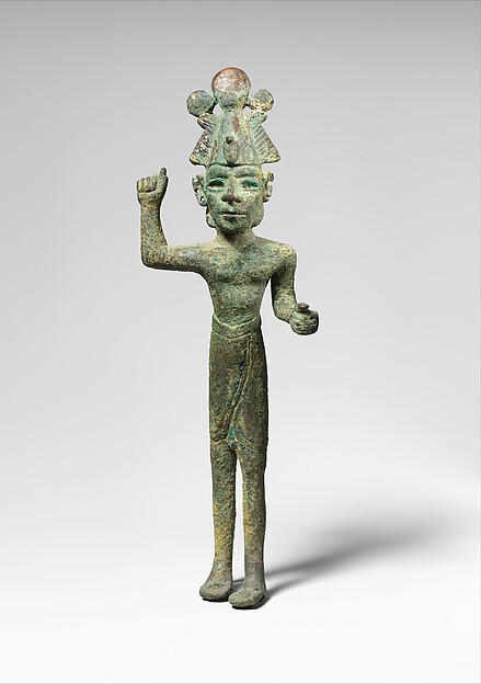
Levant · c. fifteenth–fourteenth century BCE · bronze · Metropolitan Museum of Art, 1986.42. A precise ancient findspot is not supplied in this caption.
The Metropolitan Museum of Art. Purchase, Leon Levy and Shelby White Gift, 1986. Public domain; Met Open Access, CC0. Object and image record · CC0.
Explore the religious worlds of Ugarit and Canaan →
Connect the cities with the chapters
Joshua 11 and Judges 1 preserve different narrative accounts of cities and their outcomes. Compare each named place with its own archaeological sequence. The member edition examines Hazor’s destruction and Megiddo’s ivories alongside their wider historical setting.
Joshua 11: Hazor and the northern campaign → · Judges 1: differing outcomes among the cities →