
Ancient Egypt and the Bible
Explore Egypt’s changing kingdoms, regional power and surviving records—and their connections with the biblical world.
MEMBER RESEARCH EDITIONSee the additional member research ↓
EGYPT · PHARAOHS, MONUMENTS & REGIONAL POWER
A civilization that shaped the ancient world
Across three millennia, Egypt was one of the ancient world’s great centers of power. Pharaohs commanded armies, raised monumental pyramids and temples, and controlled wealth drawn from the Nile Valley. At the height of the New Kingdom, Egyptian rule reached deep into Nubia and across much of the southern Levant, bringing cities in Canaan into its political orbit.
Egypt’s reach extended beyond conquest. Trade, diplomacy, religious traditions and artistic forms connected it with neighboring societies; in later centuries its grain helped supply the Mediterranean world. Biblical writers returned to Egypt as a place of refuge, oppression, royal power and contested alliances. Foreign dynasties eventually ruled the country, but its monuments, writing and religious traditions continued to develop—and remain central to the study of antiquity.
Timeline: kingdoms, monuments and changing rulers
- The Two Lands become a kingdom
Royal traditions join the southern Nile Valley and northern Delta; the process of state formation unfolded over generations.
- Old Kingdom: the pyramid age
Royal complexes at Saqqara and Giza express concentrated resources and ideas about kingship and the afterlife.
- Middle Kingdom: renewed royal power
Administration, literature and expansion into Nubia develop within a reunited kingdom.
- Second Intermediate Period
Regional governments coexist, including Hyksos rule in parts of the Delta.
- New Kingdom: an international power
Egypt expands into Nubia and the Levant; Karnak, royal tombs and diplomatic archives belong to this changing imperial world.
- Regional dynasties and foreign conquests
Libyan, Kushite and Egyptian dynasties, Assyrian campaigns and Persian rule reshape authority at different times.
- Macedonian conquest and Ptolemaic rule
Alexander’s conquest precedes a Greek-speaking royal dynasty that continues Egyptian temple patronage.
- Roman government and grain exports
Egypt becomes a Roman province and a major supplier of grain to the imperial capital.
Dates are approximate and vary among chronologies. Each monument and map belongs to a particular period.
The river behind the power
The Nile sustained the farmland, cities and estates that made this wealth possible. Seasonal floods deposited fertile silt; farmers planted as the water receded. Boats carried grain, people and building stone between the southern valley and northern Delta. Flood levels varied: too little water threatened harvests, while excessive flooding could damage settlements and delay planting.
Upper Egypt is south; Lower Egypt is north
Follow the Nile downstream from the southern valley into the northern Delta. The first map explains this geography; the second shows Egypt’s wider political setting around 1300 BCE.
Upper and Lower Egypt along the Nile
Upper Egypt is the southern, upstream Nile Valley; Lower Egypt is the northern, low-lying Delta. The Nile flows north toward the Mediterranean: “upper” and “lower” describe the river’s course, not the top and bottom of the map.
Map: The Bible Directory · Custom geographic orientation mapEgypt in the Late Bronze Age great-power system
A dated regional view during the New Kingdom. It should not be used as the political map for every Egyptian dynasty.
Map: Enyavar · CC BY-SA 4.0 · source and license ↗MIDDLE KINGDOM · HOUSEHOLDS & ESTATES
Letters bring life along the Nile into view
Letters and accounts preserve the work of managing land, food and family obligations alongside the royal monuments. Heqanakht’s correspondence makes those concerns tangible: renting fields and providing grain depended on both household decisions and the Nile’s changing floods.
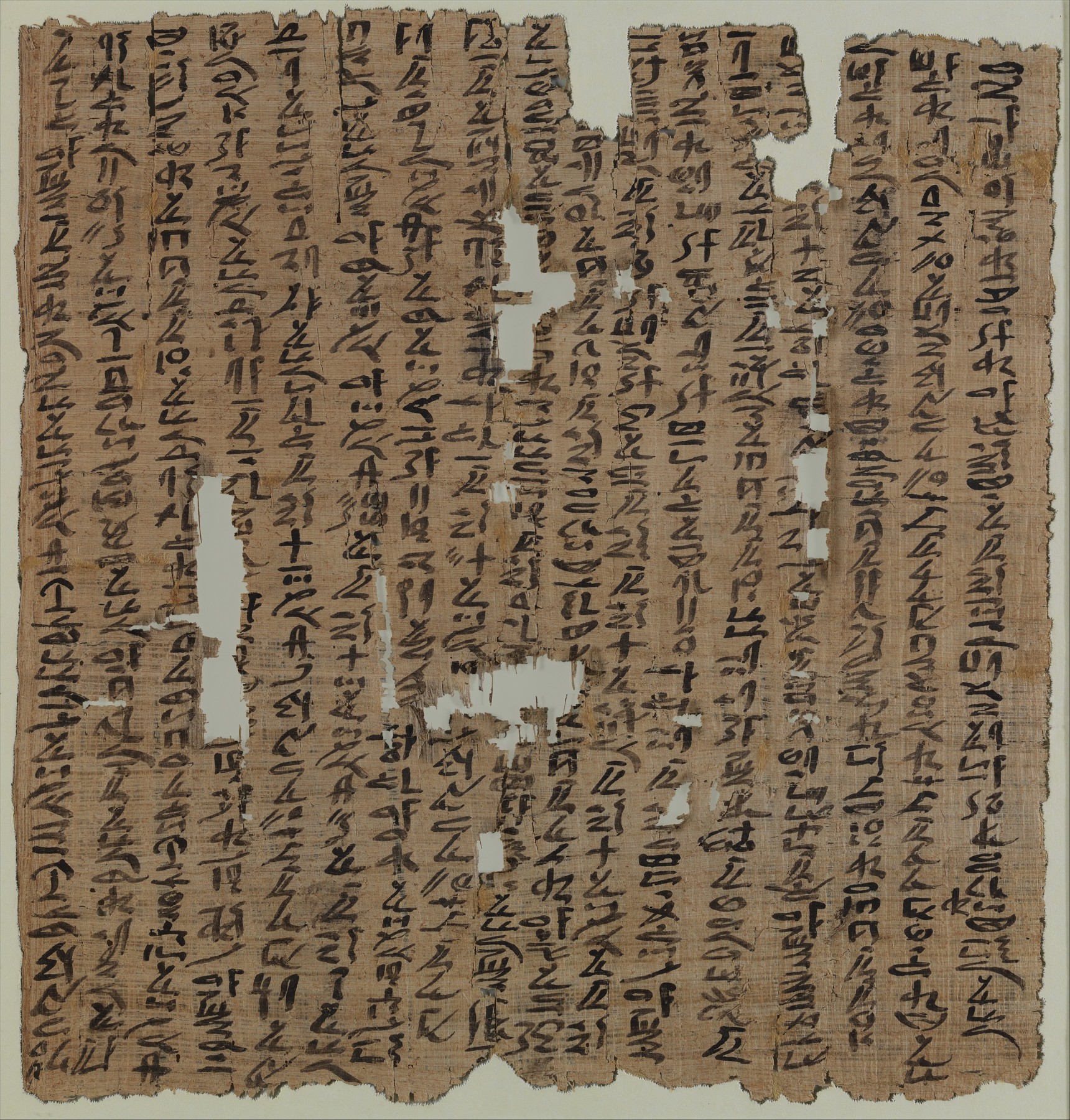
Heqanakht: land and livelihoods on papyrus
Heqanakht Letter I, ca. 1961–1917 BCE, gives instructions about renting farmland and supporting an estate’s workers. His archive connects a low Nile inundation with poor harvests and difficult decisions about grain. It illuminates Egyptian agriculture without identifying the famine in Genesis.
What to notice: The hieratic writing is arranged in columns read from right to left. This is practical correspondence, not a royal monument.
The Metropolitan Museum of Art, 22.3.516. Rogers Fund and Edward S. Harkness Gift, 1922. Public domain; Met Open Access. Existing image proportionally resized. Source · Public domain / CC0NEW KINGDOM · ROYAL COURTS & REGIONAL POWER
Royal wealth reached from palaces to distant cities
At the height of the New Kingdom, rulers controlled territories in Nubia and exercised power over cities in Canaan. Monumental temples, royal residences and diplomatic archives preserve different parts of this imperial world.
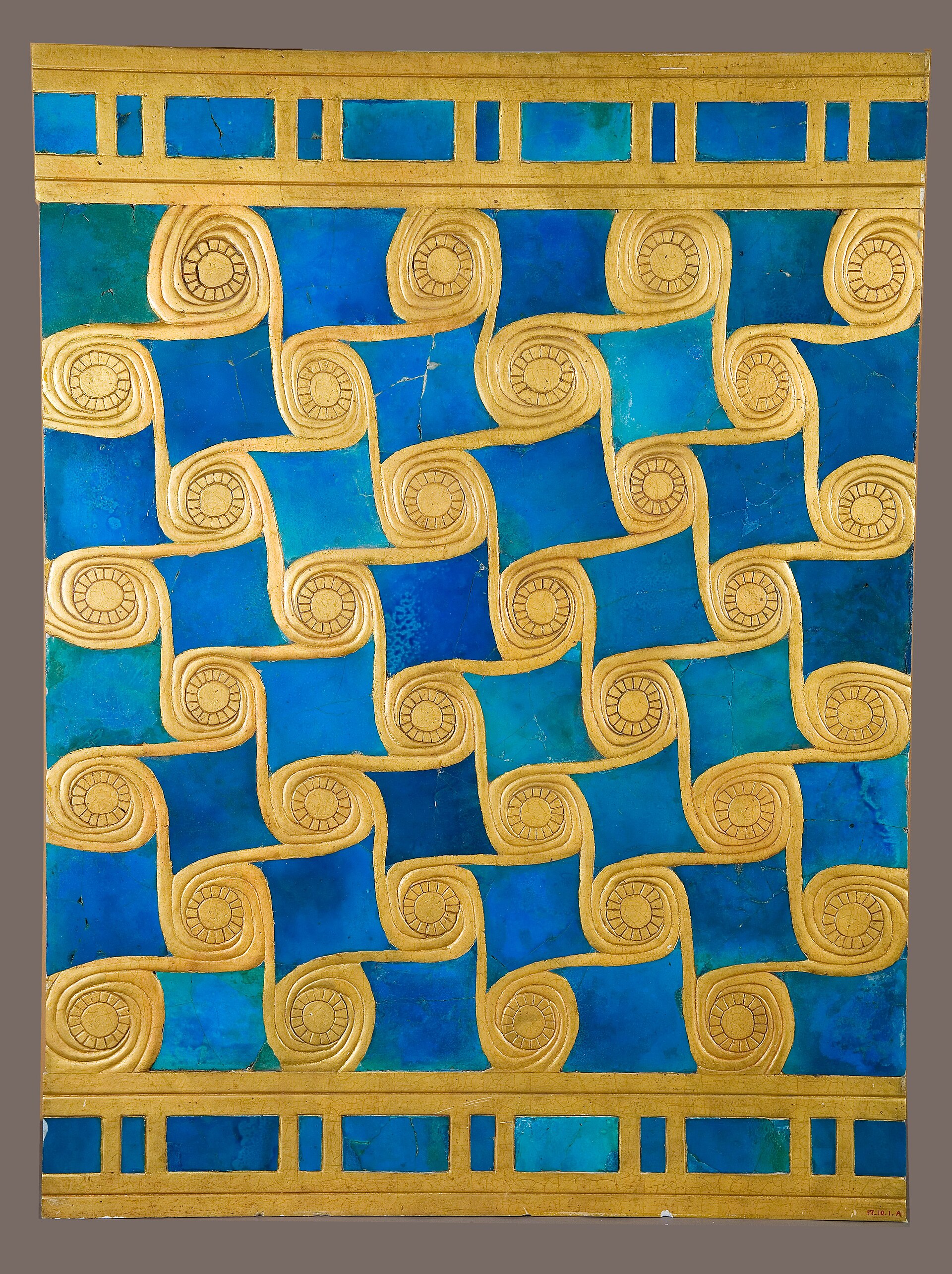
Malqata: royal celebration in blue and gold
Ancient faience tiles from Amenhotep III’s festival city, ca. 1386–1347 BCE, are arranged here with modern plaster and gold paint. The Met now considers them likely decoration from temple furniture, possibly a shrine or sacred barque, rather than a wall.
What to notice: The blue tiles are ancient; the reconstructed gold spirals explain a proposed arrangement.
The Metropolitan Museum of Art, 17.10.1a. Rogers Fund, 1917. Public domain; Met Open Access. Existing image proportionally resized. Source · Public domain / CC0Amarna: a ruler and an international archive
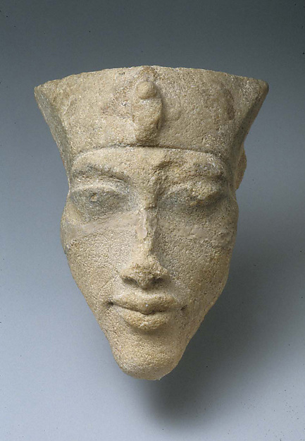
Akhenaten: a New Kingdom ruler
Head of Akhenaten, ca. 1347–1330 BCE, excavated at Amarna. The Metropolitan Museum of Art, 21.9.17.
Public domain · The Met Open Access / CC0Open the collection record ↗The Amarna letters preserve diplomacy between great kings and appeals from local rulers seeking Egyptian support. A letter from Tyre brings the relationship between Egypt’s court and a Levantine city into focus.
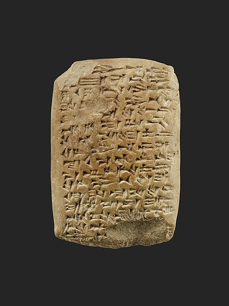
A ruler of Tyre writes to Egypt
This Amarna letter, ca. 1347–1330 BCE, preserves Abi-milku’s appeal to the Egyptian king. Written in Akkadian cuneiform, it connects a Levantine city with Egypt’s royal administration.
What to notice: A clay tablet in a diplomatic language, rather than hieroglyphs, carried this ruler’s request for protection.
The Metropolitan Museum of Art, 24.2.12. Rogers Fund, 1924. Public domain; Met Open Access. Existing image proportionally resized. Source · Public domain / CC0Explore the Amarna letters → · Locate Canaan in the Bronze Age →
ABU SIMBEL · NUBIA · THIRTEENTH CENTURY BCE
Abu Simbel: a mountain moved
Carved into a cliff. Threatened by a rising lake. Taken apart and built again.
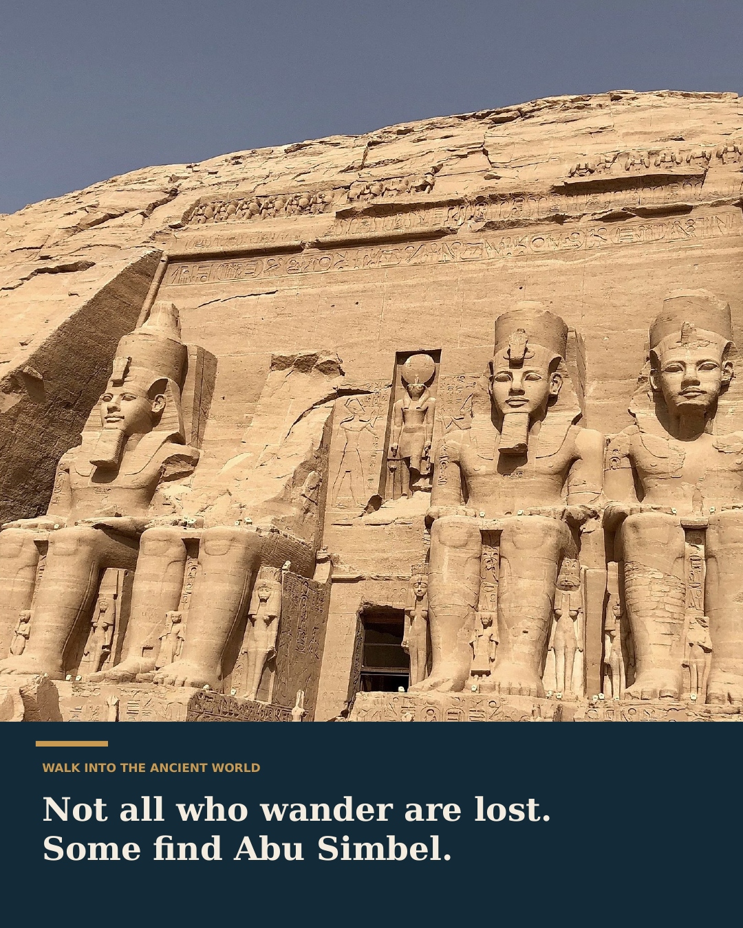
Four giants. One king.
All four seated colossi represent Ramesses II. Smaller figures beside their legs portray his mother, Queen Nefertari, and royal children; the figure above the doorway is the sun god Ra-Horakhty. Built in the thirteenth century BCE, the Great Temple honored Amun-Ra, Ra-Horakhty, Ptah, and the deified king, displaying royal power in Nubia. The nearby Small Temple honored Hathor and Nefertari.
How do you save a temple carved into a mountain?
The Aswan High Dam would put the original site underwater. Before the reservoir submerged the temples, an international rescue coordinated by UNESCO cut them into more than a thousand enormous blocks, moved them 64 metres higher, and reassembled them inside an artificial cliff. Reopened in 1968, Abu Simbel stands as an extraordinary feat of engineering and international cooperation.
PTOLEMAIC & ROMAN EGYPT · CONTINUING TRADITIONS
New rulers continued Egyptian temple traditions
Temples were houses of divine presence and major estates, with priests, offerings, workshops and farmland. Egyptian building and religious traditions continued under later dynasties. The monumental temple at Edfu belongs to Ptolemaic rule, many centuries after the New Kingdom. Its gateway and carved surfaces show how rulers continued to sponsor traditional sacred architecture.

Edfu: an Egyptian temple under Ptolemaic kings
The Temple of Horus at Edfu was built during Ptolemaic rule. This nineteenth-century photograph records its monumental entrance and carved surfaces; it is a later temple, not a structure from the Exodus narrative.
What to notice: The enormous gateway and relief-covered walls make royal ritual visible in stone.
Museo Egizio photographic archive, Turin, Album2 088. CC0; existing image proportionally resized. Source · CC0Meet Egypt’s gods and religious traditions → · Explore temples and sacred practice →
Can you crack the Rosetta Stone?
Explore a decree in two languages—Egyptian and Greek—with Egyptian written in hieroglyphic and Demotic scripts.
Egypt and the biblical narratives
Biblical accounts of refuge, departure and political alliances engage with Egypt across different eras. The history of each period provides context for those accounts; objects, inscriptions and archaeology help investigate particular settings.
Which pharaoh belongs with the Exodus narrative?
The biblical text does not name the pharaoh. Proposals depend on biblical chronology, place names, Egyptian history and archaeology; no identification commands a scholarly consensus.